Navigating unfamiliar routes.
If you want to spend your holidays away from home (especially in another country, especially in one with an unfamiliar language), and you aren't going be shepherded by your guide all the time, then you'll need a reliable tool allowing you to navigate through unfamiliar places (whether countryside or urban jungle) without any problems - a map.
Paper or digital, in the form of a mobile app or a separate navigation device, whether you travel on foot, by public transport, bicycle or car - a map will save you a lot of time, effort and nerves.
Paper maps can be found in almost every guidebook, but you must keep in mind that these are designed to give only a general idea about the place, so it's not exactly reasonable to fully rely on them.
More detailed and informative maps (either completely free of charge or for a very reasonable price) can be obtained at local tourist information offices. As a rule, you'll find a detailed map of the city center with all the tourist attractions (just what we need from the city!).
If you're mostly relying on public transportation, then you'd better look for a map with bus, tram, etc. lines and stops (and not ones with subway stations only).
Drivers' needs are slightly different
from those of the pedestrians. The sufficiently detailed maps and road
atlases can usually be found at gas stations, book- and tourist/gift
shops and newsstands.
The car rental dealer most likely won't be able to provide you with suitable maps (and why must he, really? - it's a question of money - he'll better rent you a GPS device for $10-$30 a day!).
The best maps of a particular country (as you could guess) can usually be found in this very country.
But in the 21st century the place of paper
maps is firmly occupied by digital ones.
Unlike the paper maps, they suggest us the shortest / fastest route from point A to point B, give us turn-by-turn directions and voice prompts, determine (and pretty accurately) the estimated travel time, show the nearest café, gas station, etc. They also know our current position (on a map) and road conditions (= traffic jams).
And today renting a car we've basically got to choose between two options: use a smartphone (with online or offline maps), or a stand-alone GPS device.
Smartphone owners, whose phone plans permit
reasonable use of the mobile internet, are certainly using, or at least
once tried to take advantage of available free navigation applications
(CityMaps2Go,
Google,
OffMaps,
Navfree,
Waze,
Yandex Maps, etc.).
And they all have one indisputable advantage - namely they are free. But, as already stated,
- (1) to get the most from them one must be permanently connected to the network (i.e. the existence of an appropriate cell phone plan, the usage of these services in offline mode imposes additional restrictions),
- (2) continuous exchange of information contributes to the rapid discharge of the battery.
Let's try to deal with these problems:
- (1) costs of using your usual mobile plan in a foreign country skyrocket because of roaming, so if you are going to use the mobile data during your vacations and do not want to be tied to (usually not exactly numerous) WiFi hotspots, you'd better get a SIM card of a local mobile operator just on your arrival at your destination, or even take care of it before your travel; you can read more here: Stay connected while traveling abroad;
- (2) the usage of offline maps (= Internet connection is not available) would not produce mobile communication cost increase even abroad (using GPS to determine your position on the map does not require a permanent connection to the network, but this is probably all that we've got), so at the nearest WiFi hotspot we'll have to download the map required, ask the device to get us directions to a certain place (we unable to do it without an internet connection) and - use it!
It would seem, that offline map is a perfect instrument for a traveler. But do not hurry. There are three major drawbacks to using them.
- (1) Certain features (3d, terrain, etc.) won't be available;
more on Google maps read here:
Maps for Mobile Help. Note:
Features that require a network connection – such as directions and Navigation – are not available offline.
(?!) - (2) GPS and voice directions are notorious for their ability to discharge batteries: that is particularly unpleasant while traveling and not knowing when and where you'll be able to charge your phone ( or rather your smartphone, let's call things by their proper names).
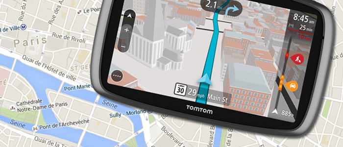
- (3) As a long-time admirer of (free) Google services, I nevertheless have to admit that they're also not without fault. Once Google Maps App sent me across all the city (my native one), I've lost about 2 hours. But no offence taken: I sort of didn't pay, they sort of provided me with some services 'as they were'. But this situation is simply impermissible on travel, especially for a driver. So in these cases it is better to use paid services, and for a driver there is nothing better, than a stand-alone GPS navigation device.
While booking a car, you can simultaneously ensure the availability (not a problem there, built-in in almost every car nowadays) and more important usability of a navigation device by renting it.
But it will cost you additional $10- $30 a day (!). This alone can bring you to the idea that perhaps you should take on your trip your own device (after all, it's portable, isn't it?).
And the two leading companies in the field are TomTom (with headquarters in Europe) and Garmin (with headquarters in the US). By the way, these big two also produce applications for smartphones. TomTom began this activity somewhat earlier, and perhaps because of the fact its applications considered a bit more advanced.
Although the latter (Garmin) is much better
known, but, when compared, the products (of approximately the same price
range) show no significant differences. Prices on TomTom devices are
almost always lower due to constant sales and discounts:
a couple of years ago on iTunes TomTom Europe
would cost you $69.99 (with 20%
discount), now it was replaced with
TomTom Go Mobile (50 miles are
free, after that one year of unlimited driving will cost you $17.99 and 3 years — $40.99 respectively) with coverage of
150 countries and according to the manufacturer:
Maps are stored on your device, so you don't need internet access or data roaming to plan a route
,
at the same time the price for
Garmin Western Europe is $69.99 (was $89.99
a couple of years ago) and
Garmin U.S.A — $49.99 (exactly the same
price as it was earlier).
 TomTom has some
more features, which can please an experienced driver: to the map of
North America they've added (in addition to maps of the US and Canada)
a map of Mexico, its IQ Routes gives you faster routes and more accurate
arrival times and its parking assist feature makes finding the nearest
parking place very easy indeed. AND it has half an hour more of battery
life, then Garmin (as we're speaking here only about a couple of
hours, so it does matter, really).
TomTom has some
more features, which can please an experienced driver: to the map of
North America they've added (in addition to maps of the US and Canada)
a map of Mexico, its IQ Routes gives you faster routes and more accurate
arrival times and its parking assist feature makes finding the nearest
parking place very easy indeed. AND it has half an hour more of battery
life, then Garmin (as we're speaking here only about a couple of
hours, so it does matter, really).
And if in the
past everything was clear and we'd used Garmin while traveling in North
America and TomTom - in Europe, so now, it would seem, we need to revise
this approach.
That's all for now. And don't forget to ENJOY YOURSELVES!

Useful Links:
Book your flight. Cheap. — Flight Search.
Find a hotel or an
apartment. —
Accommodation Search.
Internet access and
phone calls while traveling abroad — Reducing connection charges.
Best travel
insurance plans — Medical insurance abroad.
Where and when to look for the best flight deals —
Tips &
tricks for finding cheap air tickets.
Find flight deals online —
Best flight search engines and online travel agencies.
Avoid flight booking
scams — or Someone out there always wants to cheat us.


